|
|
|
GEDI GPP and ET
|
GEDI GPP and ET: A gridded daily GPP and ET dataset over the Contermious United States (CONUS)
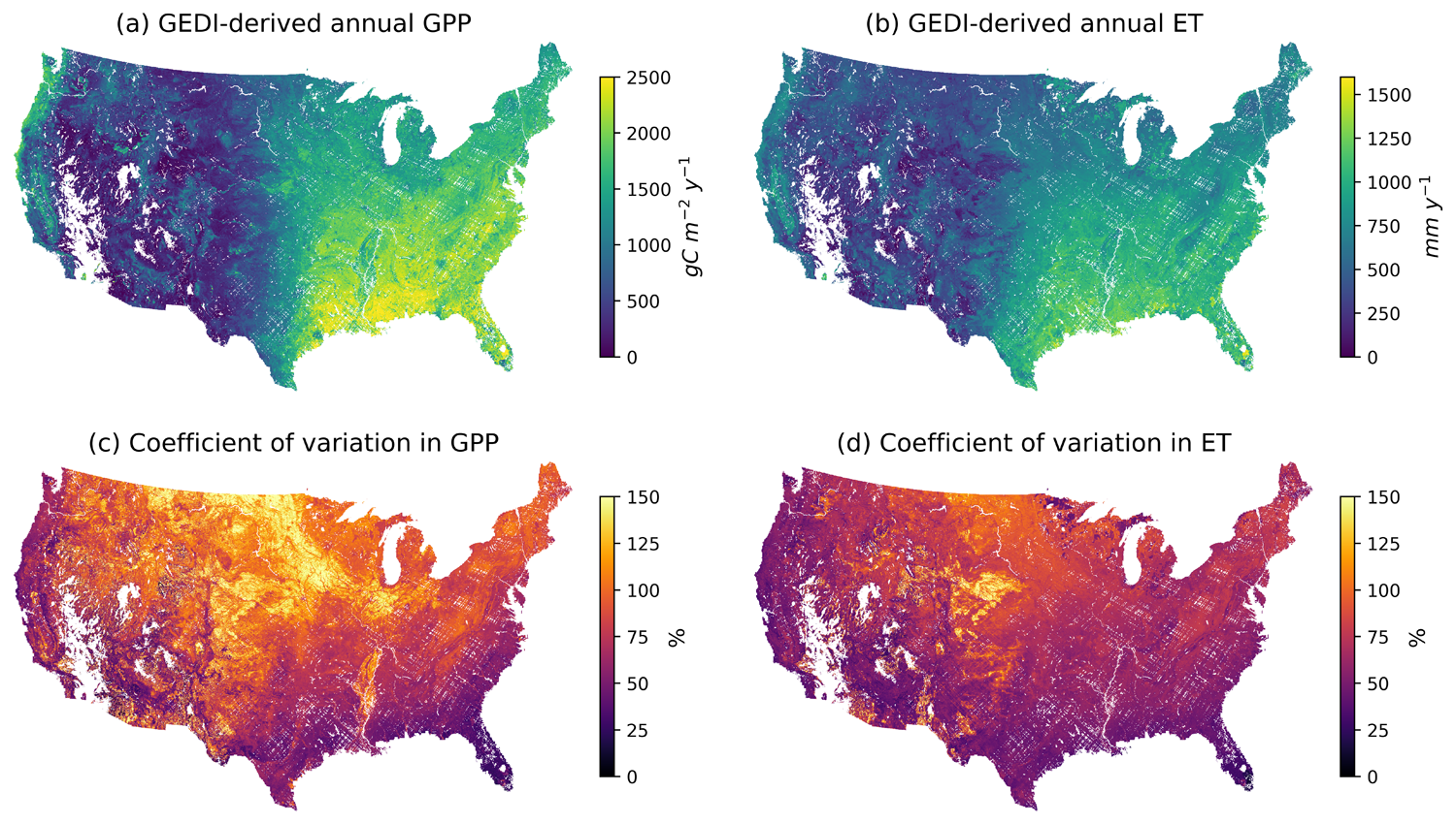
A 1 km, daily gross primary production (GPP) and evapotranspiration (ET) product for the Conterminous United States (2019-2023) Description: Upscaling carbon and water fluxes from eddy covariance (EC) sites with machine learning (ML) enables assessment of land–atmosphere exchange across broad scales. We developed new gridded flux products that incorporate canopy structure and diversity, which have been largely overlooked in previous upscaling studies. Using canopy height (RH) and foliage height diversity (FHD) from NASA’s GEDI mission, flux data from over 90 AmeriFlux and NEON sites, MODIS NIRv, and Daymet meteorology data, we trained ML models to predict gross primary production (GPP) and evapotranspiration (ET) (GPP: R² = 0.91, RMSE = 1.14 gC m-2 d-1; ET: R² = 0.85, RMSE = 0.68 mm d-1). Based on these models, we generated 1 km, daily GPP and ET datasets across the conterminous United States for 2019-2023. The products capture effects of canopy structural complexity on fluxes, seasonal dynamics, and drought resilience, providing new resources for ecosystem and Earth system studies. The methodology, validation, and spatial and temporal patterns of this product are described in our paper (Bu and Xiao, 2025).
Citation: Bu, J.*, Xiao, J. (2025) Upscaling eddy covariance measurements of carbon and water fluxes to the continental scale by incorporating GEDI-derived canopy structural complexity metrics. Remote Sensing of Environment, 329, 114930. https://doi.org/10.1016/j.rse.2025.114930. [PDF] Metadata: Spatial resolution: 1 km Fair Data Use Policy: We make the datasets available to the research community as we believe that the dissemination of the datasets can be helpful to advancement in science. If you plan to use our datasets in a manuscript or project, we request that you inform us early in your work. If our datasets are essential to your results or findings, co-authorship will be appropriate. Contact: Drs. Jingfeng Xiao and Jingyi Bu Download GEDI GPP and ET data: Please read the fair data use policy above before you download the data. This data set is available at the Global Ecology Data Repository (Download GEDI GPP and ET data). |